KX Community

Find answers, ask questions, and connect with our KX Community around the world.
KX Community Guidelines

Home Forums KX Solutions Altitude in Offline Maps

Tagged: ,

  • Altitude in Offline Maps

    Posted by simonkaplan on October 2, 2024 at 11:48 am

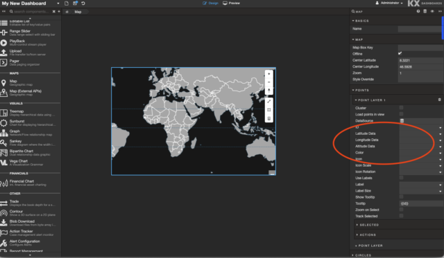
    Hi all, I’m having a bit of an offline maps problem. Offline maps allow one to set up a point layer, where each point has an associated latitude, longitude and altitude. (see attached image). Lats/lons work fine but regardless of what we put in the altitude fields, when we rotate the map we can see all the points are at an altitude of zero.

    How do we ‘elevate’ points?


    thanks for any advice you can share


    cheers Simon

    simonkaplan replied 1 week, 1 day ago 2 Members · 2 Replies
  • 2 Replies
  • khennessy

    Member
    October 4, 2024 at 12:32 pm

    In the current map solution we are just tracking the altitude value at present


    There are couple things here that you could do to demonstrate altitude

    1) You could use a data-driven line gradient – this would color the line based on the current altitude

    2)You could use a secondary chart to show the altitude


    If you need anymore details here just let me know

    Regard

    Kieran


  • simonkaplan

    Member
    October 9, 2024 at 1:11 am

    Thanks Kieran – we went with the 2-chart solution, very early EG attached. Locations shown on a map, and also in a 3D widget of the ‘flightspace’. See attachment.

Log in to reply.